Suffolk Walks & Bigod’s Way

Bigod’s Castle, the remains of Roger Bigod’s Castle, rebuilt on the site of previous castles in 1294, form the focal point for all the walks described.

Bigod’s Way (10 miles)

The main loop encircles Bungay and can be reached from Bigod’s Castle along any access paths shown on the map. The Bigod Way passes through areas of outstanding natural beauty. The route offers a variety of wildlife, rare plants, and many sites of historical interest. At rambling pace this walk can be completed in 4/5 hours.

Update: The footbridge at Earsham Mill has now been repaired and it is now possible to cross this bridge and follow the path across Fen Farm out to Flixton Road (B1062) from where you may return to Bungay or continue your walk over the road and up Constitution Hill where you turn left and follow the paths and roads back to Bungay via St. Margaret’s Road.

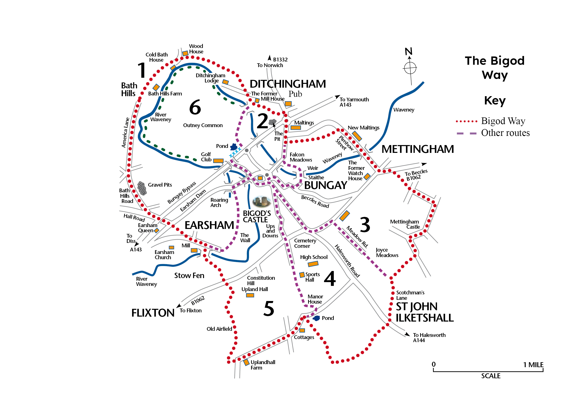
Download the map pdf here.

Bath Hills Walk (5.5 miles)

These lovely hills are steeped in history and are arguably one of the most attractive areas in England. South facing, they have been vineyards for centuries even in Roman times. Roger Bigod had extensive vineyards here in 1240. In Georgian times a cold spring bath existed close to Bath House and Bungay was a famous spa town. The “stinking iris”, a rare plant, is also to be found in this area.

Rabbitskin Run (2.6 miles)

This short walk is associated with George Baldry, a local folk hero whose life story is featured in the book ‘The Rabbitskin Cap’. At the foot of Bath Hills and on the edge of Outney Common the foot path crosses the Waveney by two narrow footbridges. Here stood the Mill House where George had his boats and workshops and where he strove for the secret of perpetual motion.

Mettingham Castle Ramble (5.0 miles)

At its eastern extremity, the Bigod Way passes close to the ruins of Mettingharn Castle. In 1342 John de Norwich castellated his residence and added a massive gateway with portcullis. It is this structure that remains and is visible from the northern approach.

Scotchman’s Lane (4.8 miles)

After leaving Bungay over the Joyce Meadows this walk links with Scotchman’s Lane, a former track leading to Mettingham Castle. For many years this track has been blocked and overgrown. Recent clearance work has revealed a most attractive footpath.

Constitution Stroll (4.6 miles)

This route takes in high ground just to the south of Bungay and includes Constitution Hill. From this vantage point impressive views of the town are visible, as well as a magnificent view of Earsham Church across the marshes.

Riverside Walk

A new walk was recently opened around the common area by kind permission of the common owners. This area that follows the River Waveney is particularly picturesque and many interesting features can be seen including the home of Sir Rider Haggard.
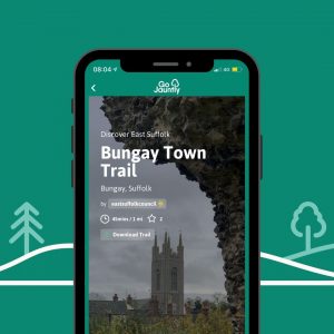
Go Jauntly

Walking in Bungay has just become easier thanks to a partnership between East Suffolk Council and walking App Go Jauntly.  You can embark on a journey through the history and greenspaces of Bungay with two fantastic walks now available on the Go Jauntly app.

Take a Short walk around Bungay or follow the Town Trail to explore Bungay Castle, learn about visit from the Black Shuck and shop at the weekly market and local shops en-route.

Go Jauntly is a free community-based app to promote walking, wayfinding and nature connection. You can find local walks created by people who know and love them, discover the greenest walking routes from A to B, create your own jaunts and enjoy outdoor adventures with friends and family.

Go Jauntly is available to download, for free, on the App Store https://apps.apple.com/us/developer/go-jauntly-ltd/id1150399086 and the Google Play Store Go Jauntly: Discover Walks – Apps on Google Play

Waveney Valley Walks

Free PDF Download

Download a free information leaflet containing walks in and around Bungay, including the Bigod Way.

Download PDF


Country Code

Whilst enjoying any of these walks, please adhere to the country code

Leave no litter, guard against all risks of fire, protect wildlife, plants and trees, respect the life of the countryside, keep to paths, keep dogs under proper control, fasten all gates, avoid damaging fences, hedges and walls, go carefully on country roads and safeguard water supplies.
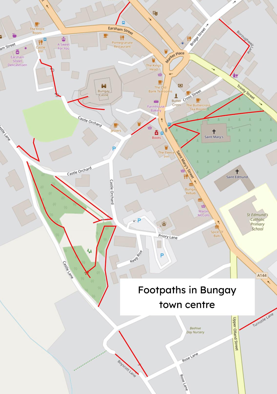
 

Bungay Town Centre

On completing the Bigod Way kick back in Bungay’s town centre at one of our many excellent cafes, restaurants or pubs.  You’ll receive a friendly welcome, lots of locally sourced food and drink and a well earned rest.

Bungay Town Trail

Exploring historic buildings and places of interest in Bungay’s ancient town centre.

Bungay is a fine old market town, rich in history. The town centre is officially recognised as a Conservation Area by English Heritage.

The Town Trail includes virtually all of Bungay’s historic buildings, churches, the River Waveney and shops of special interest. The routes are ideal for visitors to the town and offer a chance to explore the ‘old world charm’ that is unique to Bungay.

Both the eastern route and the western route start at the Market Place and at normal walking pace the trail can be completed in under two hours.

For a deeper dive into the history and architecture of the many buildings you will see as you explore Bungay, the Bungay Conservation Area document provides a fascinating look at their place within the vernacular, as well as highlighting the details that make our built heritage so rich. Download the document here.

Buttercross

Bungay’s famous Buttercross was rebuilt after the Great Fire of Bungay in 1688. It Is situated in the Market Place and provides a prominent starting point for the Town Trail. The seats under the Buttercross afford a resting place where leaflets can be studied prior to setting out. A weekly Thursday market has been held on this site since 1382. In earlier times the Buttercross was also used as a prison with a dungeon beneath. This was replaced in Georgian times by an iron cage. Within this area are many fine shops offering personal attention typical of Bungay.

Borough Well

From the Butter Cross the Town Trail follows Cross Street, passing the Buttercross Tea Rooms. Here the keys for the Borough Well can be obtained. Entry to Borough Well Lane is made alongside Poulton Hall, a former Methodist Chapel, now used as auction rooms. Descending the steps you are led to the Borough Well which provided the public water supply from Roman times until 1923, when water was piped to the Town from Outney Common. The well is Tudor in construction and was restored by The Bungay Society in 1935.

Bridge Street

A right turn at the end of the lane leads down Bridge Street, one of Bungay’s most historic and unspoilt street scenes. This was a busy commercial area in Victorian times with numerous shops and pubs, but is now more residential in character, Ron Buck’s antique displays and the popular Chequers Inn are highly recommended. Further down the street at No 34 lies the Music House. Here the famous statesman and author, Chateaubriand, took refuge during the French Revolution in 1757.

Falcon Meadow – Riverside Walk

After crossing the River Waveney by footbridge, cross the road and take a sharp right past the old Falcon Inn and through a kissing gate to the Falcon Meadow. Here, alongside the Waveney and amongst the lush water meadows, are outstanding views of the Town including St Mary’s and Holy Trinity Churches. Falcon Meadow was bought by a community group who formed The Falcon Meadow Trust to preserve the meadow for the future. The Falcon Meadow Trust work hard to make the meadow as species rich as possible.  Linger a while here and look closely to discover the rich bird and insect life as well as the wildflowers.

Bungay Staithe

The walk continues along the Bigod Way access path, following the river bank to the weir. Here the river can be recrossed to reach Bungay Staithe, an area that brought considerable trading wealth to Bungay until navigation ceased in 1934. Due to the quality of local oak trees and its position on the Waveney, Bungay was for centuries involved in the construction of wherries. In 1860 William Brighton, who built the famous wherry Albion, worked in the Bungay Staithe area. On leaving the Staithe in a southerly direction, the route passes the Mill House now, like all of the surrounding buildings, a private residence. This ancient Mill ceased production in 1960 when the Mill stream was filled.

Staithe Road

A right turn towards the Town leads to Staithe Road and the delightful group of almshouses. These were built in 1848 by Eliza Dreyer and endowed for the benefit of poor widows in Bungay. At the end of Staithe Road the classical Queen Anne lines of Trinity Hall dominate the view.

Holy Trinity Church

The Saxon round tower predates the Castle and is the oldest complete structure in the Town, On the outside door a brass plate commemorates Holy Trinity’s close escape from the ravages of the Great Fire of Bungay. Visitors are welcome inside where monuments to former worthy citizens of Bungay are in evidence. Donations to the upkeep are appreciated.

St. Mary’s Church & Priory

A left turn through St. Mary’s Churchyard passes the ruins of the Benedictine Priory founded by Gundreda, wife of Roger Bigod, in 1160. St. Mary’s Church, with its prominent tower, dominates the local landscape and is the most handsome building in Bungay. The Church dates from the 12th century onwards and was severely damaged in the Great Fire after which the south aisle and the lower were partially rebuilt. St. Mary’s is famous for a visit by the “Black Dog of Bungay” in 1577 which, during a violent storm, terrified the congregation. In 1981 the Church was taken over by the Redundant Churches Fund now the Churches Conservation Trust) and is supported locally by the Friends of St. Mary’s. Visitors are welcome to view the Church.

The Market Place

A right turn at the gates of St. Mary’s Churchyard will take you to the Market Place, a townscape which has remained unchanged for centuries. Prominent buildings include two old coaching inns, the King’s Head and the Three Tuns, both of which are still a vital part of the hostelry scene. On the other side of the roundabout is Wightmans furnishing shop, a handsome Victorian building. The “roundabout” is distinguished by the Black Dog of Bungay weather vane. On this site stood the old Corn Cross, made redundant in 1609. and more recently the Town Pump, which was dismantled by order of the Town Reeve in 1933.

Broad Street & Cork Bricks

Alongside the Three Tuns runs Broad Street, once the main route for livestock heading towards the Market. On the right, depicted by a wall plaque, is the old Fisher Theatre which was opened in 1658. This popular venue attracted famous actors who appeared with the Fisher family until the Theatre’s closure in 1844.  After several incarnations as a service building the Theatre was bought by the Bungay Arts and Theatre Community Trust to return it to its original purpose.  It is a much loved asset to the town hosting live performances of music and drama as well as art exhibitions. Cross over to visit the Green Dragon, a little further along Broad Street towards Outney Common,  an independent pub which brews real ale on the premises. Turn back towards the Town and just before Cork Bricks is the Bungay Town Council offices, which also housel the Town Museum.

Cork Bricks is a charming short alley way, so called because the wife of the doctor who lived in the rather grand house on your right (now flats) was very ill and couldn’t stand to hear the clatter of horses hooves outside her window. So the doctor had the alley repaved in bricks made from cork. (Long since replaced by regular bricks sadly).

Earsham Street

This is one of the Town’s busiest streets with a rich diversity of specialist shops and commercial premises. The route follows the right side of the street passing a variety of independent shops to St. Mary’s House. From here there is an excellent view of the fine terrace of 17th century cottages. Cross the road to Scott House near Cock Bridge. This old house was formerly the residence of John Barber Scott, famous diarist and philanthropist. The return journey will enable a visit to more local independent shops, including a very popular delicatessen where you can buy the local Baron Bigod cheese.  At the 16th century Castle Inn, turn right into the yard and follow the footpath to Bigod’s Castle.

Bigod’s Castle & Visitors Centre

Here on the high ground, virtually surrounded by the Waveney and a site of earlier fortifications, Hugh Bigod, as feudal lord, built a massive Norman keep in 1165. From this site the truculent Hugh terrorised the local Saxons and at times illegally occupied the castles at Norwich and Orford. In 1174 he supported Henry II’s rebellious sons in armed insurrection, which ended in surrender of the Castle to the King’s forces and the payment of 1,000 Marks for his disloyalty. Hugh Bigod was killed in Syria on a crusade in 1178, at last fighting for his King.

A second castle was built by Roger Bigod in 1394, which protected the town with curtain walls and provided the famous twin towers of the gate house which remain today. Further information can be found on the Bigod Castle plinth by the entrance to the site. Following a successful bid for European 5b matched funding in 1997 by the Bungay Castle Trust, money was obtained for the conversion of a derelict garage site, on the approaches to the Castle, into a visitors centre and cafe, which provides access to the Castle.

Baron Bigod’s Kitchen – Cafe and Visitor Centre

The visitor’s centre, officially opened in July 2000, provides the entrance to the Castle and improved facilities for visitors. These include the cafe,tourist information, a loo and a model of medieval Bungay produced by The Bungay Society.

Castle Hills

From the visitors centre, turn right into Castle Orchard leading to the Castle Hills. These were earth works constructed by the Saxons to defend the town against the Danes. On the western side there are fine views of the Waveney Valley across to Earsham.

Upper Olland Street

On leaving Castle Hills by the main gate, follow Priory Lane and turn right at the junction with St. Mary’s Street and enter Upper Olland Street. The street name is probably a derivation of “oak lands”, the wood being used to build wherries in the Staithe area. At the junction of Upper and Lower Olland Streets stands one of the oldest buildings in Bungay, now a motor accessory shop. Further down the street there is an interesting mixture of shops, the largest being the site of the old Nursey & Son, a factory shop specialising in high quality sheepskin products. The shop is now a hairdresser but the old Nursey workshop remains above where the orders for the online Nursey sheepskin business are fulfilled.

Emmanuel Church

A classic Congregational Chapel dating from 1518. In recent centuries independent church communities have exercised a strong influence in the Town. John Childs, a printer whose business was the forerunner of Clays Ltd – one of the largest book printers in Europe and Bungay’s largest employer,  broke the bible monopoly enabling bibles to be sold at a much cheaper rate, worshipped here. His tombstone near the Chapel records his death in 1853 and there is a beautiful commemorative window in the Lecture Hall at the rear of the Church. Visitors are welcome inside and to the beautiful gardens to the front of the Church.

Dinky’s Garden

From Emmanuel Church cross the road and return to the Town, taking a right turn through Turnstile Lane with its pretty cottages, and left at the junction. Here is Dinky’s Garden, named after Dinky and Sid Payne, champion fund raisers with their stalls in the Angel yard.  You can rest a while here and enjoy the peace among the plants and flowers maintained by Bungay In Bloom, a group of volunteers who plant up all of Bungay’s hanging baskets and planters.

St. Mary’s Street

Continue along St. Mary’s Street to St. Edmund’s RC Church. Land in this area was set aside by the Duke of Norfolk and a small chapel was opened in 1823. Frederic Smith, a former Town Reeve, rebuilt and renovated the Church, and the present Church was opened in 1894. The martyrdom of St. Edmund is depicted in sculptural relief. From St. Edmund’s cross to the other side of the street to visit this busy section of shops housed in a variety of architectural styles. Continue past two of the Town’s old pubs, The Fleece and The Swan. Walk on to Farm House Bakery in the Market Place where a plaque on the wall marks the outbreak of the Great Fire of Bungay in 1638. From here cross the road to finish your journey where it began at the Butter Cross.

Footpaths in Bungay town centre

Compiled using maps from openstreetmap.org, find more Bungay footpath maps at footpathmap.co.uk

Bungay town trail audio guides

Visit explorewaveneyvalley.com and listen to Bungay town trail audio guides


More walks

Explore more walks and trails at visitwaveneyvalley.co.uk including this PDF for spending half a day in Bungay